Terrainium has been working with Find Your Feetto design and deliver the maps forWilder Trails– an initiative that showcases trails and routes around Tasmania that may otherwise remain unknown, forgotten or overlooked by the ‘sexier’ places or races.
Maps are free to download and enjoy from the Wilder Trails website – just follow the links or click the badges on each map/route below.
Scan or click this code to get the map on your phone
Cradle Mountain – Lake St Clair National Park, with its ancient rainforests and alpine heaths, is home to the world-famous Overland Track and iconic Cradle Mountain. Part of the Tasmanian Wilderness World Heritage Area, the park is one of the state’s most special places, where ancient pines fringe glacial lakes and icy streams cascade down rugged mountains. Dramatic Cradle Mountain is the rugged jewel of the park.
Scan or click this code to get the map on your phone
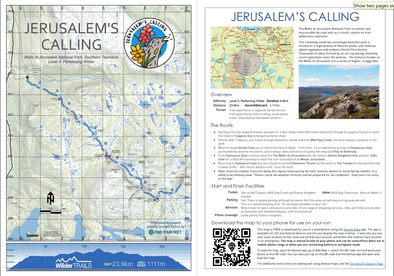
The Walls of Jerusalem National Park is remote and inaccessible by road and, as a result, retains its true wilderness character.
This relatively small but stunningly beautiful park is located on a high plateau of dolerite peaks, and features alpine vegetation and endemic Pencil Pine forests. Thousands of lakes formed by an ice cap during relatively recent glaciation cover the plateau. The features known as the Walls of Jerusalem are a series of higher, craggy hills.
Scan or click this code to get the map on your phone
Our Fields of Gold route is named in honour of the picturesque beauty of Tarn Shelf and the Mt Field alpine regions come Autumn. Each year, in the weeks leading up to Anzac Day on the 25th April the Northofagus gunnii turns. Nicknamed ‘Fagus’ by our local residents, this plant is Australia’s only cold climate winter-deciduous tree, growing at a very narrow altitude band in the mountains.
Scan or click this code to get the map on your phone
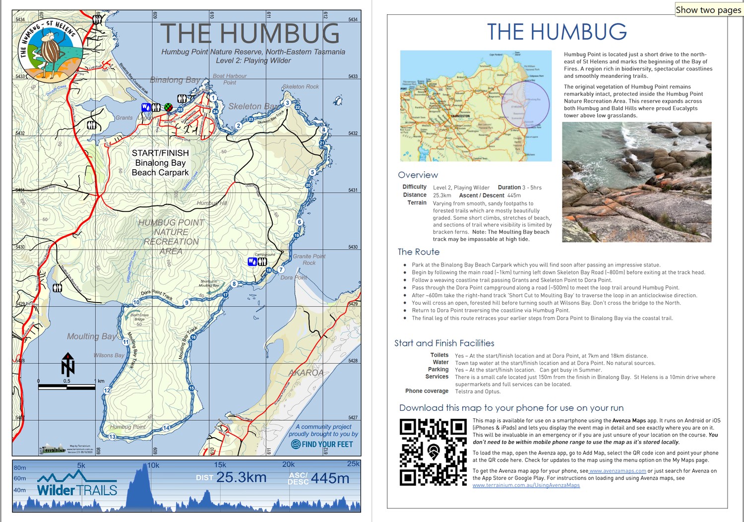
Humbug Point is located just a short drive to the north-east of St Helens and marks the beginning of the Bay of Fires. A region rich in biodiversity, spectacular coastlines and smoothly meandering trails.
The original vegetation of Humbug Point remains remarkably intact, protected inside the Humbug Point Nature Recreation Area. This reserve expands across both Humbug and Bald Hills where proud Eucalypts tower above low grasslands
Scan or click this code to get the map on your phone
Freycinet National Park is home to dramatic pink granite peaks, secluded bays, white sandy beaches and abundant birdlife. Situated on Tasmania’s beautiful east coast, the park occupies most of the Freycinet Peninsula and looks out to the Tasman Sea from the eastern side and back towards the Tasmanian coastline from the west.
Scan or click this code to get the map on your phone
The geology of the Wellington Park provides the physical foundation for the landscape, ecosystems and character of the Wellington Range – the sheer dolerite columns of the Organ Pipes, hidden caverns of Lost World, familiar features of Collins Cap and Collins Bonnet, the band of sandstone beneath the Wellington Range and mudstone waterfalls in the foothills.
Scan or click this code to get the map on your phone
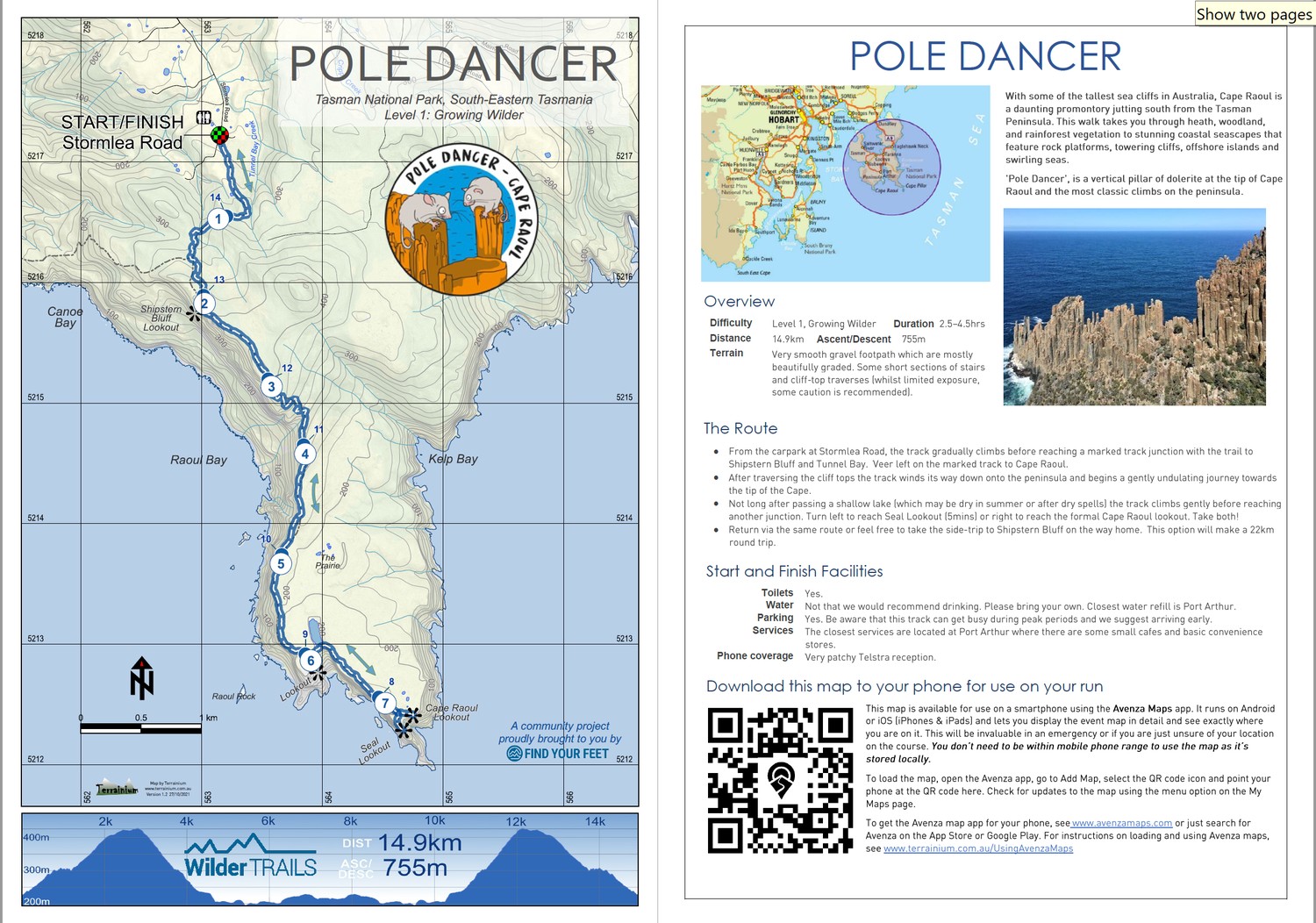
With some of the tallest sea cliffs in Australia, Cape Raoul is a daunting promontory jutting south from the Tasman Peninsula. This walk takes you through heath, woodland, and rainforest vegetation to stunning coastal seascapes that feature rock platforms, towering cliffs, offshore islands and swirling seas.
‘Pole Dancer’, is a vertical pillar of dolerite at the tip of Cape Raoul and the most classic climbs on the peninsula.
Scan or click this code to get the map on your phone
The Labillardiere Peninsula is situated in the South Bruny National Park. The route completes a clockwise loop of the peninsula providing magnificent views of the D’Entrecasteaux Channel and the rugged mountains of Tasmania’s Southern Ranges. There are deserted rock beaches to explore as southern swells crash onto the western coastline. Return along a beautiful, twisting single track through grassland and Eucalyptus forest along the eastern side of the peninsula.
Scan or click this code to get the map on your phone
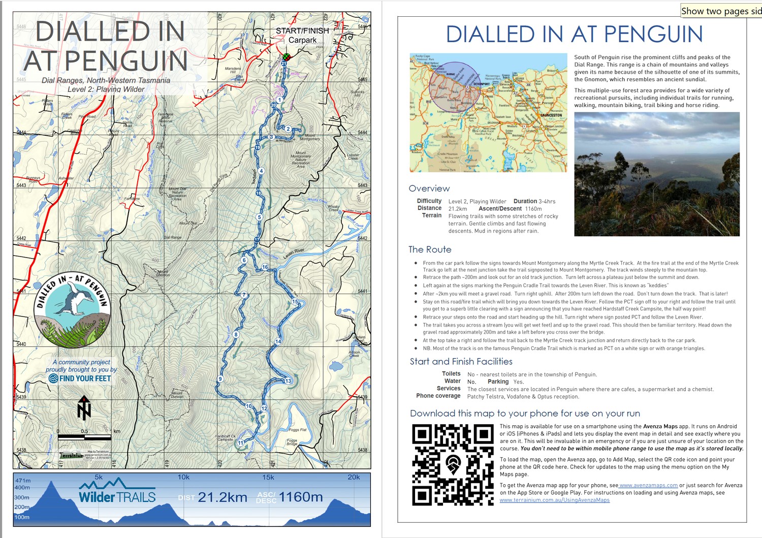
South of Penguin rise the prominent cliffs and peaks of the Dial Range. This range is a chain of mountains and valleys given its name because of the silhouette of one of its summits, the Gnomon, which resembles an ancient sundial.
This multiple-use forest area provides for a wide variety of recreational pursuits, including individual trails for running, walking, mountain biking, trail biking and horse riding.
Scan or click this code to get the map on your phone
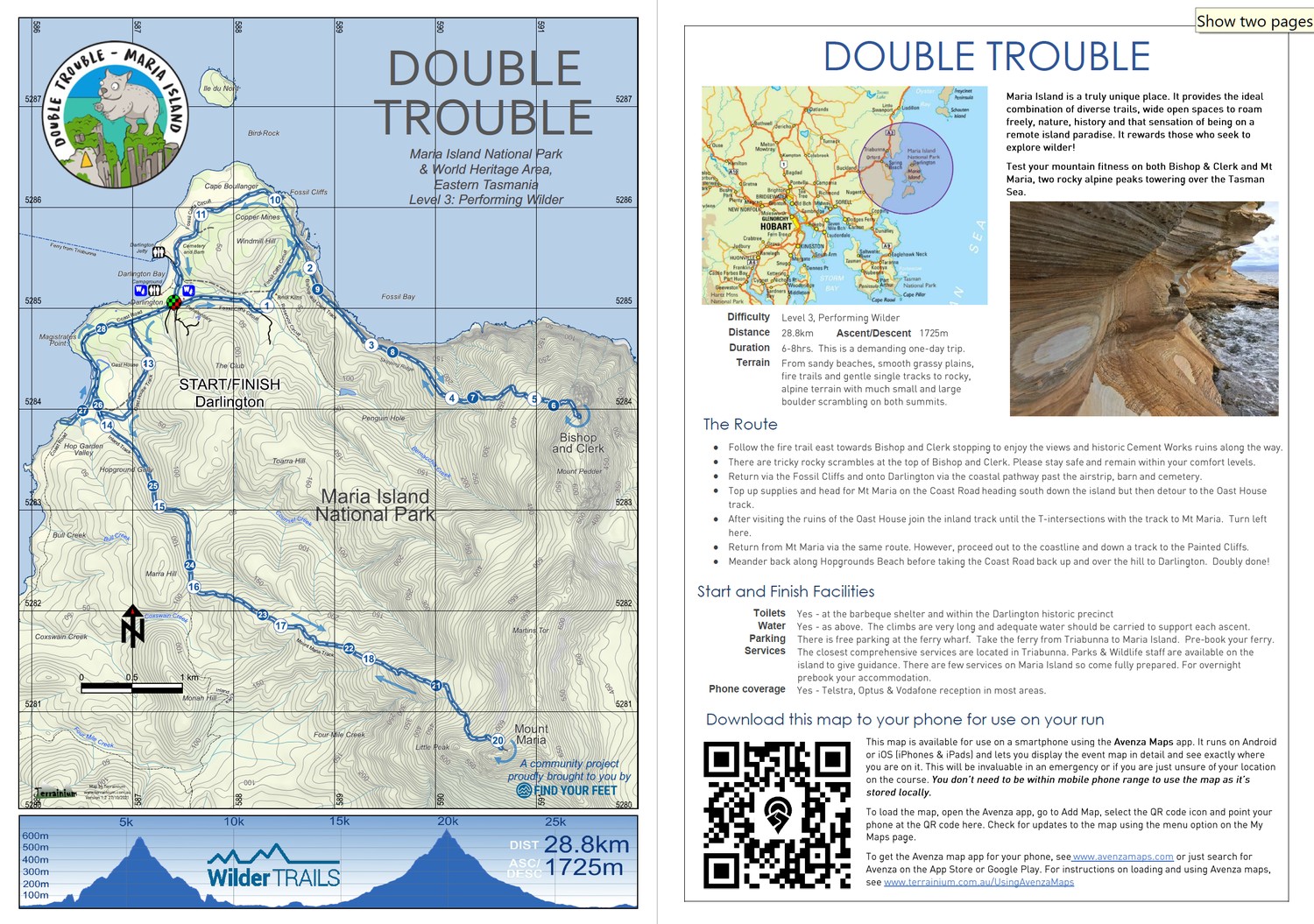
Maria Island is a truly unique place. It provides the ideal combination of diverse trails, wide open spaces to roam freely, nature, history and that sensation of being on a remote island paradise. It rewards those who seek to explore wilder!
Test your mountain fitness on both Bishop & Clerk and Mt Maria, two rocky alpine peaks towering over the Tasman Sea.
Scan or click this code to get the map on your phone
Carved out by glaciers over millions of years, Lake St Clair is Australia’s deepest freshwater lake. The environment around Lake St Clair is among Tasmania’s most spectacular. Deep glacial lakes are fringed by dense forests of ancient pines, and the high mountains provide a dramatic backdrop. The Mount Rufus summit cairn is very impressive! In clear weather other mountains can be seen in every direction, including nearby Mount Hugel, Mount Olympus and Frenchmans Cap.
Scan or click this code to get the map on your phone
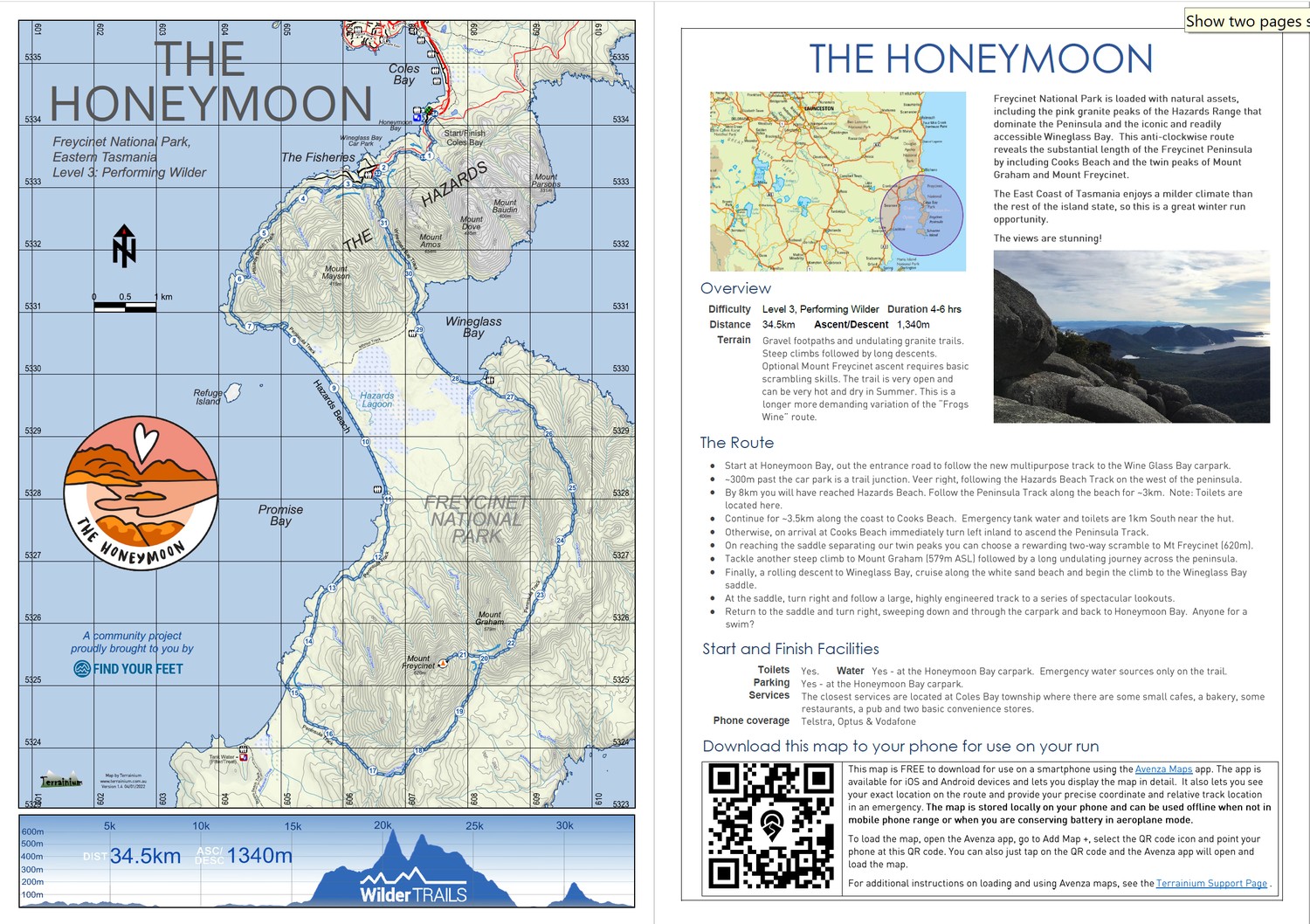
Freycinet National Park is loaded with natural assets, including the pink granite peaks of the Hazards Range that dominate the Peninsula and the iconic and readily accessible Wineglass Bay. This anti-clockwise route reveals the substantial length of the Freycinet Peninsula by including Cooks Beach and the twin peaks of Mount Graham and Mount Freycinet.
The East Coast of Tasmania enjoys a milder climate than the rest of the island state, so this is a great winter run opportunity.
Scan or click this code to get the map on your phone
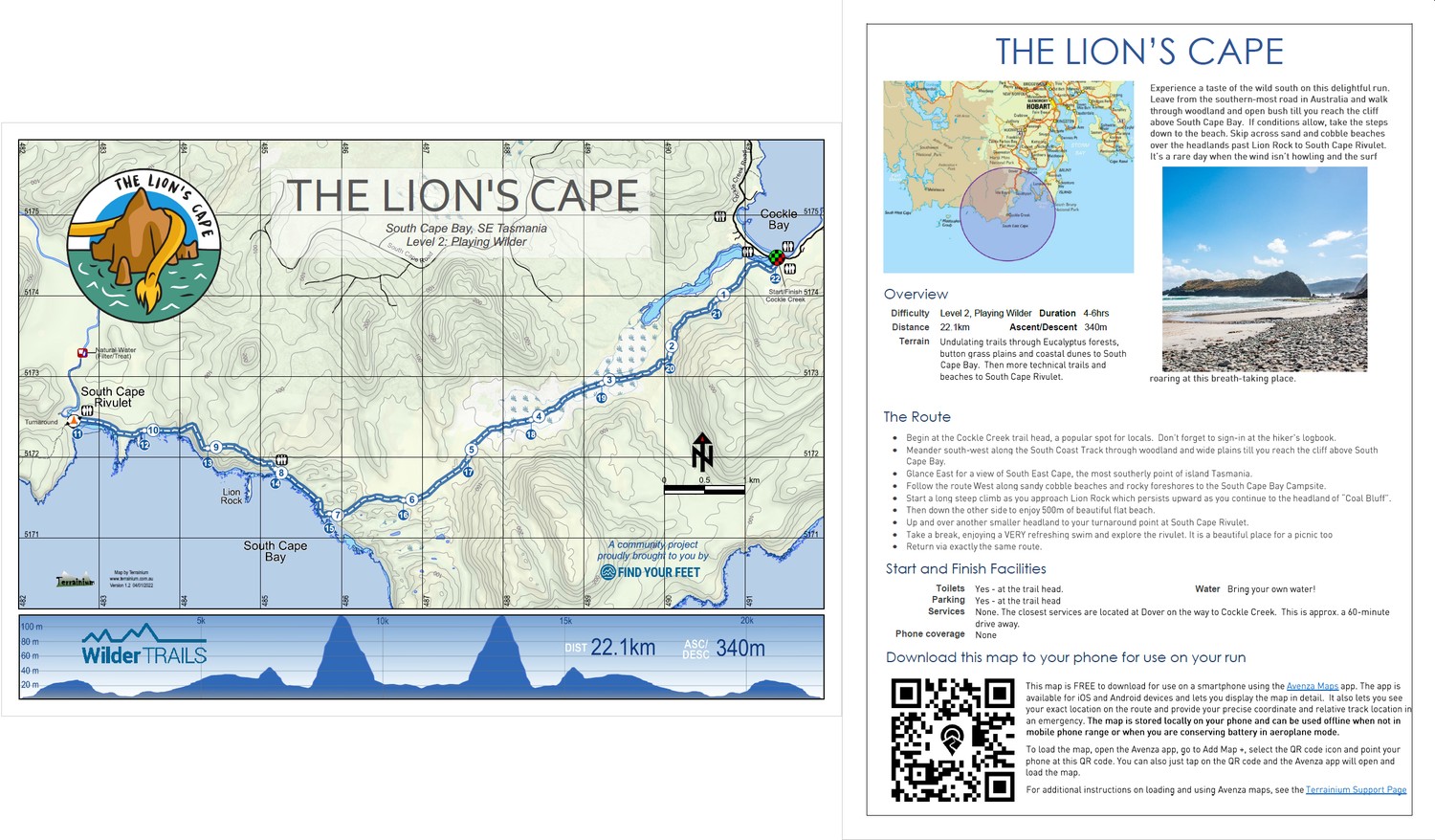
Experience a taste of the wild south on this delightful run. Leave from the southern-most road in Australia and walk through woodland and open bush till you reach the cliff above South Cape Bay. If conditions allow, take the steps down to the beach. Skip across sand and cobble beaches over the headlands past Lion Rock to South Cape Rivulet. It’s a rare day when the wind isn’t howling and the surf roaring at this breath-taking place.